
Recently published in Earth Surface Processes & Landforms: Anastamosing Channels in the Lower Neches River Valley, Texas. The abstract is below:
Active and semi-active anastomosing Holocene channels upstream of the delta in the lower valley of the meandering Neches River in southeast Texas represent several morphologically distinct and hydrologically independent channel systems. These appear to have a common origin as multi-thread crevasse channels strongly influenced by antecedent morphology. Levee breaching leads to steeper cross-valley flows toward floodplain basins associated with Pleistocene meander scars, creating multi-thread channels that persist due to additional tributary contributions and ground water inputs. Results are consistent with the notion of plural systems where main channels, tributaries, and sub-channels may have different morphologies and hydrogeomorphic functions. The adjacent Trinity and Sabine Rivers have similar environmental controls, yet the Trinity lacks evidence of extensive anastomosing channels on its floodplain, and those of the Sabine appear to be of different origin. The paper highlights the effects of geographical and historical contingency and hydrological idiosyncrasy.
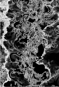
Grayscale slope map of study area showing the large depressions in the lower Neches River floodplain (black=zero slope to white = maximum slope = 0.06).
Reference: Phillips, J.D., 2014. Anastamosing channels in the lower Neches River valley, Texas. Earth Surface Processes and Landforms 39, 1888-1899.