
geology

ANASTAMOSING CHANNELS

Recently published in Earth Surface Processes & Landforms: Anastamosing Channels in the Lower Neches River Valley, Texas. The abstract is below: 


Active and semi-active anastomosing Holocene channels upstream of the delta in the lower valley of the meandering Neches River in southeast Texas represent several morphologically distinct and hydrologically independent channel systems. These appear to have a common origin as multi-thread crevasse channels strongly influenced by antecedent morphology. Levee breaching leads to steeper cross-valley flows toward floodplain basins associated with Pleistocene meander scars, creating multi-thread channels that persist due to additional tributary contributions and ground water inputs. Results are consistent with the notion of plural systems where main channels, tributaries, and sub-channels may have different morphologies and hydrogeomorphic functions. The adjacent Trinity and Sabine Rivers have similar environmental controls, yet the Trinity lacks evidence of extensive anastomosing channels on its floodplain, and those of the Sabine appear to be of different origin. The paper highlights the effects of geographical and historical contingency and hydrological idiosyncrasy.


SOUTH PARK & GEOMORPHOLOGY


I got a few e-mails last week about fluvial geomorphology—not because of anything I have done, or any current issues or unresolved questions in that field. No, it was because a character in the irreverent Comedy Central show South Park was identified on the show as a fluvial geomorphologist. Apparently that gives us a measure of popular culture street cred.

South Park character Randy Marsh, in his pop singer Lorde disguise.

An actual geomorphologist named Randy (R. Schaetzl, Department of Geography, Michigan State University).


SCALE RATIOS


In fluid dynamics the Reynolds Number is the ratio of inertial to viscous forces, and is used to distinguish laminar from turbulent flow. Peter Haff (2007) applied this logic to develop a landscape Reynolds number, and also suggested how other generalized “Reynolds numbers” can be constructed as ratios of large-scale to small-scale diffusivities to measure the efficiencies of complex processes that affect the surface. As far as I know, there has been little follow-up of this suggestion, but the premise seems to me quite promising at an even more general level, to produce dimensionless indices reflecting the ratio of larger to smaller scale sets of processes or relationships. The attached file gives a couple of examples. 


CHANGING LANES

Some form of the diagram below is often used as a pedagogical tool, and to represent a theoretical framework, in fluvial geomorphology, hydrology, and river science. It is called a Lane Diagram, and originated in a publication by E.W. Lane in 1955:

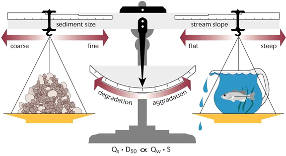
The diagram shows that stream degradation (net erosion and incision) and aggradation (net deposition) responds to changes in the relationship between sediment supply (amount of sediment, Qs, and typical sediment size, D50) and sediment transport capacity (a function of discharge or flow, Qw, and slope, S). The diagram is a very helpful metaphor in understanding the sediment supply vs. transport capacity relationship, and its effects on channel aggradation or degradation.

DYNAMIC EQUILIBRIUM (?) IN RIVERS

Nicholas Pinter, a Southern Illinois University geomorphologist, gave a nice talk yesterday on rivers and flooding in the 21st century as part of UK’s Water Week. Pinter’s talk got me to thinking about the concept of “equilibrium” in environmental systems and what it means to both geoscientists and laypersons. Pinter correctly noted that rivers tend toward dynamic equilibrium, and more specifically, dynamic metastable equilibrium. This means three things: First, the system (river) is more or less constantly changing (the dynamic part). Second, equilibrium is of the type envisioned in mathematics and systems theory—that is, a state or condition the system settles into after a change or perturbation, with no further connotation other than that the response to the change has run its course (I’ve called this “relaxation time equilibrium” in my work). Third, “metastable” means that these equilibrium states are not necessarily stable and self-maintaining, and may be sensitive to future disturbances—even relatively small ones. Pinter’s message is that dynamic equilibrium in rivers means that rivers are constantly changing.

THE TRIAD

Explaining and understanding Earth surface systems almost always requires some triangulation between three different sets of factors. The first, examples of which are shown on the lower left corner of the triangle below, are general principles and relationships that apply everywhere and always. Second, on the upper point, are environmental factors--characteristics of locations and regions such as climate, geology, etc. On the lower right of the triangle is the third set of factors, related to past events and time available for the system to develop.

This can be generalized as laws, place, and history, as shown below. 

Subscribe to geology