By Guy Spriggs
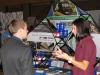
On a windy day in February 2012, Department of Geography associate professor Jeremy Crampton met his Intro to GIS (Geographic Information Systems) students on the main lawn in front of Administration Building for a demonstration of citizen remote sensing.
This cutting edge experiment didn’t require any million dollar equipment, however. Crampton and his students were able to survey the western border of UK’s campus using only a camera, a 2-liter soda bottle, a balloon, rubber bands, and string.
By simply suspending a camera from the balloon, this technique makes it possible to not only physically map an area, but to use other forms of recording (such as thermal imaging) to capture data on